

Visualizing heatwaves: Partnering with UNICEF to protect children from climate change


2023 was the warmest year on record, and over 820 million children were exposed to dangerous heatwaves, a stark reminder of climate change's immediate impact. This crisis demands urgent action and innovative solutions, especially considering children's heightened vulnerability to extreme heat.
Unlike adults, children's bodies adapt more slowly to temperature changes and struggle to regulate internal temperature effectively. This physiological difference puts infants and young children at higher risk of heatstroke, dehydration, and other severe heat-related illnesses, which can be fatal. Moreover, heatwaves disrupt education by reducing school attendance and impairing learning outcomes, further compromising children's well-being and future prospects.
At Tryolabs, we've partnered with UNICEF Data & Analytics Team to develop an open-source visualization tool that tracks heatwave indicators and children's exposure to extreme temperatures from the 1960s to the 2020s. This tool aims to provide crucial insights to policymakers and researchers worldwide, helping to drive informed decision-making and targeted interventions.
Our partnership with UNICEF has been particularly fruitful, spanning multiple projects that demonstrate their trust in our capabilities. Previously, we collaborated with UNICEF on a significant project to identify schools using satellite imagery. This successful collaboration laid a strong foundation for our current partnership, showcasing our ability to deliver robust, innovative solutions to complex challenges.
Bringing complex data to life
Our visualization tool transforms intricate climate and demographic data into an accessible, interactive format. It comprises two main sections, each offering unique insights into global heatwave trends and their specific impact on children worldwide.
We built this tool using standard web technologies, including HTML for markup, JavaScript for client-side scripting, and CSS for styling. At the core of the project is an interactive map powered by the open-source Leaflet library and the GeoRaster plugin, which work together to efficiently process and display vector and raster data. All spatial data is hosted on Azure Blob Storage, and the tool itself is easily accessible through GitHub Pages. To enhance the user experience and ensure fast data loading, we implemented caching mechanisms and leveraged Cloud Optimized GeoTIFFs for the raster data.

Explore the visualization tool
Uncover crucial insights into children's heatwave exposure through the interactive map.
Heatwave indicators
This section provides a global, pixel-level overview of heatwave trends spanning several decades. Users can explore how key indicators such as frequency, duration, severity, and extreme temperature days have changed over time. Each pixel on the map represents an area of approximately 11 km x 11 km, offering a highly detailed visualization of local climate patterns.
A color-coded system helps users easily identify regions most impacted by these heatwaves, with the intensity of the colors representing the severity of the data. For more detailed analysis, users can export the data as GeoTIFF files, making it easier to explore specific indicators across different decades.
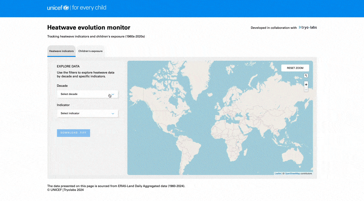 Heatwave indicators section of the visualization.
Children's exposure
This section shifts focus to the impact of heatwaves at the country level, particularly on the child population. It includes an interactive map that shows the number of children, as of 2023, living in areas where heatwave indicators have increased by a certain percentage since the 1960s.
Users can filter the data by specific indicators and percentage thresholds to focus on different aspects of exposure. The map uses color coding to visually represent the percentage of children affected by heatwaves in each country, making it easy to identify regions with the highest levels of exposure. For more detailed insights, users can click on any country to access specific data about children's exposure or view global statistics for a broader understanding of the issue.
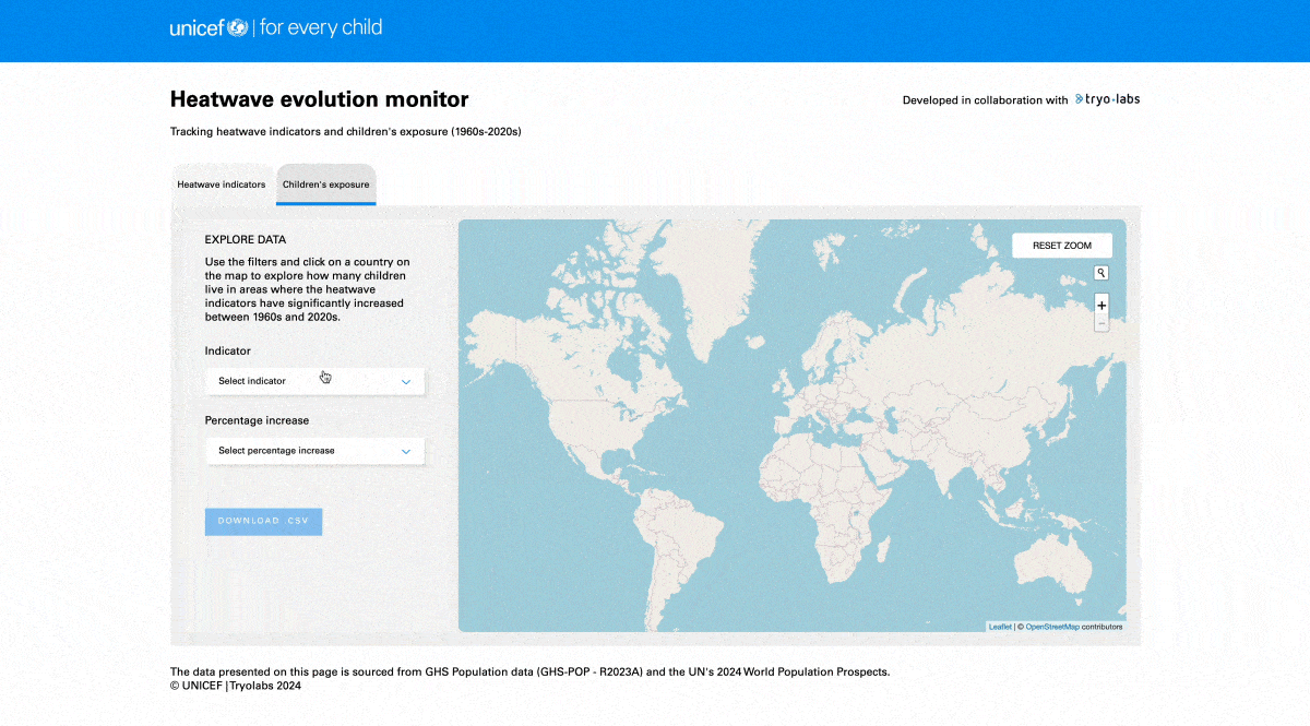 Children's exposure section of the visualization.
By providing these interactive features, our tool empowers researchers, policymakers, and the public to explore the data, identify trends, and make informed decisions to protect children from the increasing threat of heatwaves.
Importantly, we've made this tool open-source, aligning with our commitment to transparency and collaborative problem-solving. By opening up the codebase, we invite the global community of developers, researchers, and climate activists to build upon our work. This approach not only fosters innovation but also ensures the tool can evolve to meet future challenges, maximizing its potential impact in protecting vulnerable populations. The open-source nature of the project allows for continuous improvement, adaptation to new data sources, and the possibility of extending the tool's capabilities to address other climate-related issues affecting children worldwide.
Data and methodology
To effectively monitor children's exposure to heatwaves, we first needed to define and measure these events accurately. We consider a "heatwave" as a period of at least three consecutive days where the maximum daily temperature ranks in the top 10% of recorded temperatures for a specific location. This definition uses 15-day average temperatures from 1960 to 1990 as a baseline for comparison. According to the World Meteorological Organization, using long-term averages (typically over 30 years) helps smooth out short-term fluctuations and provides a clearer understanding of underlying climate patterns.
We focus on four main indicators to assess heatwave impact:
Heatwave indicators
- Frequency: Average number of heatwaves per year
- Duration: Average number of days a heatwave event lasts
- Severity: Average temperature above the local 15-day average during the heatwave (in °C)
- Extreme heat days: Average number of days exceeding 35°C per year
These indicators help us understand how frequently heatwaves occur, as well as their duration and intensity—crucial factors that significantly impact children's health and well-being.
Our tool combines climate data with demographic information to provide a comprehensive picture:
Data sources
Climate data: We use the ERA5-Land Daily Aggregated dataset, which provides high-resolution global climate data from 1960 to 2024. This dataset allows us to track long-term temperature trends with a resolution of ~11 km.
Population data: To understand how these climate trends affect children, we integrate child population data from the GHS Population dataset and the United Nations' 2024 World Population Prospects.
By combining these datasets, we can identify not just where heatwaves are becoming more frequent or severe, but also how many children are potentially affected in each area. To ensure consistent spatial analysis, the heatwave indicators derived from the ERA5-Land dataset were resampled to match the ~1 km resolution of the population data.
Our approach leveraged the strengths of a diverse, skilled team, bringing together experts from various fields, including Data Scientists and geospatial professionals. This collaboration was crucial in assessing and integrating the most effective technologies, tools, and resources, ensuring the accuracy and reliability of our visualizations. We ensured our team members integrated smoothly into this project, delivering efficient and impactful solutions from day one.
Data challenge
The ERA5-Land Daily Aggregated dataset provides global temperature data on a grid with 3,181 cells across and 2,260 cells down. Analyzing this data every day for 30 years adds up to a staggering 78.7 billion data points!
This immense volume of data highlights the complexity and the need for a robust Data Engineering pipeline to ensure actionable insights can be extracted effectively.
This comprehensive approach to data collection and analysis enables the visualizer to provide accurate, detailed insights into the growing impact of heatwaves on children worldwide, forming a solid foundation for informed decision-making and targeted interventions.
Building on a foundation of AI for Good
This project builds upon our extensive experience in the AI for Climate Change and Social Good space. Our previous work includes:
- Partnering with Open Climate Fix to predict solar panel generation
- Utilizing computer vision to aid lion conservation efforts with LINC
- Developing a wildfire alerting system for a prevention startup in the USA to detect fires in video streams across vast forest areas
Our diverse portfolio of AI for Good projects has equipped us with the technical skills and domain knowledge necessary to tackle complex, multi-faceted issues like climate change and its impact on vulnerable populations.
Looking ahead
By leveraging this visualization tool, UNICEF launched a high-impact media campaign that garnered attention from major outlets like The Guardian, The New York Times, Bloomberg, and Forbes.


The tool’s insights aim to inform policymakers, particularly in the context of the Paris Agreement, by prioritizing children's heat exposure in climate plans and raising public awareness about the critical climate issues affecting children.
Although our current focus has been on heatwaves, we recognize that children are vulnerable to a wide range of climate and environmental hazards. This project has underscored the importance of a reliable and reproducible Data Engineering pipeline for scaling and sustaining similar initiatives. Collecting and processing satellite data on a global scale over long periods presents significant technical challenges and demands considerable resources.
Future projects could benefit from optimizing workflows for data acquisition, preprocessing, and spatial operations, which would enable faster iterations, improved scalability, and enhanced reproducibility. This approach would be especially beneficial for organizations like UNICEF as they transition from isolated, targeted efforts to consistent, reproducible information workflows.
Join the effort
The tool we've developed with UNICEF is just the beginning. We invite you to consider how climate change is impacting your own community. Whether it's floods, hurricanes, wildfires, or other climate-related events, understanding their impact on various populations is crucial.
At Tryolabs, we're committed to leveraging AI and Data Engineering to address these complex challenges. Our work with UNICEF on heatwave visualization, along with our other AI for Good projects, demonstrates the potential of technology to drive positive change on a global scale.
We extend our gratitude to UNICEF for their trust and continued collaboration over the years. Together, we're demonstrating the power of partnership in addressing global challenges.
If your organization is tackling similar issues, we're ready to help unlock the potential of AI and Data for a more sustainable future.

Let’s create meaningful solutions leveraging AI and Data

Terms and Conditions | © 2026. All rights reserved.